
Private ownership of land in the British colonies of North America, provided self-sufficiency for many and extravagant wealth for a few. The idea of land as property came from England and accurate descriptions of property and its boundaries are essential. For this reason, surveyors were essential not just in the newly acquired lands of North America (and other British Colonies) be even in the home country.
American surveying is based on common practice in England, but the environment in North America is vastly different from what English surveyors were trained to deal with. In England, surveyors were primarily engaged in measuring and subdividing valuable properties that were already bounded with such things as walls and hedgerows. The instrument of choice was the delicate, accurate, and expensive theodolite which allowed the surveyor to sights on two landmarks and measured the intervening angular distance along a graduated scale. In America, surveyors often needed to establish boundaries within a vast wilderness that was often difficult to traverse and offered none of these convenient waypoints. Their instrument of choice was the relatively rugged and inexpensive magnetic compass. With it they measured the angular distance between a landmark and magnetic north. American surveys were thus inevitably affected by magnetic variation.
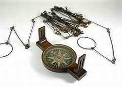
A surveyor’s compass has two essential elements: a magnetic needle for determining magnetic north, and a pair of vertical sights for sighting along a line. Often referred to as a circumferentor, this instrument originated in England shortly before 1610 and is not known for precision. As William Gardiner explained in 1737, a compass might be used for commons, roads, or wastelands, but “is by no means a fit Instrument for taking a Plan where exactness is required; because we can’t be certain of it giving any particular angle so near as two degrees.” In America, however, land was plentiful and small deviations were accepted in the interest of expediently conducting surveys, especially in the wilderness. Unfortunately, the magnetic compass also has a fundamental flaw that literally meant some surveys were only good for a very short time (if at all) – Magnetic Variation.
Now, unless you commonly navigate off road (especially by air or by sea), chances are you aren’t all that familiar with magnetic variation. At most places on the Earth’s surface, the compass doesn’t point exactly toward geographic north (toward the rotational pole). The deviation of the compass from true north is an angle called “magnetic declination” or “magnetic variation”. It has been a nuisance to navigators for centuries, especially since it varies with both geographic location and time. It might surprise you to know that at very high latitudes, the compass can even point south!
Declination is simply a manifestation of the complexity of the geomagnetic field. The Earth’s dipole (caused by is not perfectly aligned with the rotational axis of the Earth) is believed to be generated by electric currents in the conductive iron alloys of its core, created by convection currents due to heat escaping from the core. The Earth is thus able to generate magnetic fields through the motion of electrically conducting fluids. Magnetic variation (also known as magnetic declination) is the difference between magnetic north as defined by the compass needle and true north as defined by the earth’s axis of rotation. European navigators had encountered variation in the fifteenth century and found that it varied from one place to another. Henry Gellibrand in London in the early seventeenth century found that variation varied with time as well as with space.
It’s the change in variation over time that is most concerning to most surveyors but sometimes, ore deposits and other magnetic material close to the surface also result in local variations and with a large enough tract of land (say a square mile), these variations may occur WITHIN A PIECE OF PROPERTY BEING SURVEYED. As the English surveyor John Holwell reported in 1678, the magnetic needle “doth vary much in some Grounds more than in others.” Couple this with the fact that the magnetic north pole (point where compass needle points) moves about 34 miles each year, and you can quickly see why relying on compass bearings alone can be problematic.
Recognizing the problems that variation, the Royal Society of London recommended in 1670 that precise meridians be made in several places in England so that variation could be determined from time to time. This means that most 18th Century surveyors were both celestial navigators (sighting stars to determine both True North and Latitude) as well as surveyors using the compass and chain to map the land. Surveyors observe the azimuth of the sun then the azimuth of Polaris (the North Star) and note any differences between those angles and the readings of their compasses. Determining magnetic variation seems easy in theory, but it was difficult in practice. For the surveyors who tackled the much-disputed boundary between Maryland and Pennsylvania in 1750–51, the problem was beyond their means. Time and again while at New Castle and again at Fenwick Island at the eastern end of the line, these men observed the North Star by night and magnetic variation by day, and got different results every time. If the accomplished surveyors employed for this important boundary had such trouble with magnetic variation, it is not surprising that common surveyors working on properties of lesser value ignored the matter altogether but this lead to boundaries that seemed to move over time.
After the Revolution, the federal land office recommended that public lands west of the original thirteen colonies be divided into townships six miles square “by lines running due north and south, and others crossing these at right angles.” It went on to say that surveyors “shall pay due and constant attention to the variation of the magnetic meridian, and shall run and note all lines by the true meridian, certifying with every plat what was the variation at the time of running the lines thereon noted.” This was an attempt to avoid the problem of magnetic variation. Similar language appeared in the land ordinance that the Continental Congress enacted in 1785. The question remained, however, as to how to practically account for True North when even the world’s best surveyors had difficulties.
David Rittenhouse and his brother Benjamin developed a compass in which the North-South axis of the needle ring could be rotated relative to the line of sight, and thus be used to offset magnetic variation. They then went on to develop a surveyor’s compass equipped with a nonius scale that could be used to obtain greater precision— allowing bearing to be sighted to the minute (1/60th of a degree). It was likely David Rittenhouse who invented the vernier compass although he never discussed it in any of his manuscripts. This instrument made compass (or plane table) surveying as accurate as geodesic surveys of the time. Nonius refers to Pedro Nuñez, a sixteenth-century Portuguese mathematician who described a technique for interpolating between divisions on a larger graduated scale. Vernier refers to Pierre Vernier, a French military engineer who described a different solution to the problem of interpolating in 1631. Vernier’s design came into use in the eighteenth century and was known as both a nonius and a vernier scale.
While the vernier compass was an American invention, somewhat
similar instruments were available in England and Ireland. George
Adams in London offered a “small surveying compass, or portable theodolite, with a nonius,” as well as an “Improved circumferentor” that enabled surveyors to take angles “with or without the needle” and “with much greater accuracy than by the needle alone.” An Irish surveyor named John Hood devised a “Compass Theodolite” that was designed to compensate for magnetic variation; it could be had from two instrument makers in Dublin, Edward Spicer and James Lynch.
In 1791, as Andrew Ellicott was about to lay out the city of Washington along the Potomac, Jefferson told him to ascertain a true meridian and pay attention to variation. Ellicott soon found that the “magnetic variation at this place is somewhat uncertain, arising no doubt from some local cause.” On his map of the area, he reported that he had drawn a true meridian line by astronomical observations, run the several boundaries with his geodetic transit instrument, determined the angles of the streets “by actual measurement” (presumably with his common theodolite), and “left nothing to the uncertainty of the Compass.”
In 1786, the American Philosophical Society published a paper
written by Patterson that described a way to find the meridian by
observing the pole star. Observations of the sun might give the most accurate results, Patterson said, but they require “time, attention and instruments” that surveyors can seldom command. His method, on the other hand, was easy enough for surveyors to use and “will generally give the variation of the needle true to a single minute of a degree.” To help surveyors use this method, Patterson provided a table giving the azimuth of the pole star at 20-minute intervals, for latitudes 30°, 35°,40°, 45°, 50°, and 55° north.
Because of the significance and wide distribution of private property in America, surveyors played an important role in American culture. And because these surveyors used magnetic compasses, their lines could not be recovered unless magnetic variation was taken into account. Imprecise surveys opened “a Door for endless Litigation.” American surveyors began discussing magnetic variation in the 1740s, but it was the authorization of the federal land survey in 1785 that inspired the instruments and techniques that gave them a convenient means to locate true north and to compensate for magnetic variation. The various components had long been known, but the whole came together only in a context where skilled mathematicians and instrument makers—several of them affiliated with the American Philosophical Society—addressed a need that was not simply technical, but economic, social, and political as well.
Want to have the
Regimental Brewmeister
at your site or event?
You can hire me.
https://colonialbrewer.com/yes-you-can-hire-me-for-your-event-or-site/
