
The colonies of Maryland and Pennsylvania both claimed the land between the 39th and 40th parallels according to the charters granted to each colony. In 1632, King Charles I gave Cecilius Calvert a land grant for a colony in America to be named Maryland. The boundaries for Calvert’s land were: in the north the 40 degree north latitude line; in the south by the Potomac River and the latitude through Watkins Point on the Eastern Shore; in the east, the Atlantic Ocean; and, in the west, by a meridian through the source of the Potomac River. Three of these borders were created by natural landmarks and were easy to determine exactly when Calvert’s land began. Nearly 50 years later in 1681, King Charles II gave William Penn a charter for a colony would be named Pennsylvania. Three of the boundaries for Penn’s land were quite easy to measure: in the north, Penn’s land ended at the 43 degree north latitude line; in the west, the land reached until a meridian five degrees west of the Delaware Bay; and in the east, the boundary was marked by the Delaware Bay. The southern boundary extended eastward along the fortieth parallel of north latitude until it intersected an arc extending in a 12-mile radius from the courthouse in New Castle, which is now in Delaware.
The dispute between the Penns and the Calverts began because they both claimed the land between the 39th and 40th parallels according to the charters granted to each colony. One of the reasons why this land dispute was so heated is that the city of Philadelphia (then capital of Pennsylvania) falls within the disputed territory and both states wanted to claim it. In 1732 the proprietary governor of Maryland, Charles Calvert, signed an agreement with William Penn’s sons which drew a line somewhere in between and renounced the Calvert claim to the Delaware River. Later Lord Baltimore claimed that the document he signed did not contain the terms he had agreed to, and refused to put the agreement into effect. Beginning in the mid-1730s, violence erupted between settlers claiming various loyalties to Maryland and Pennsylvania.
The hostilities launched Cresap’s War, also known as the Conojocular War, which was series of skirmishes between the two colonies. In 1736, the Maryland militia got involved and the Pennsylvania militia followed in 1737. Although the militias stopped fighting in 1738, after King George II enacted a cease-fire, it would take more than another decade to fully end the dispute. In 1750, King George II stepped in again to create a truce which granted the Penns the borderline land, but no one knew for sure where the boundary line was. As part of the settlement, the Penns and Calverts commissioned Charles Mason and Jeremiah Dixon to survey the newly established boundaries between the Province of Pennsylvania, the Province of Maryland, the Old Dominion of Virginia. By 1767 the surveyors had run their line 244 mi (393 km) West from the Delaware border, every fifth milestone bearing the Penn and Calvert arms.
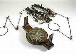
Charles Mason and Jeremiah Dixon were two of England’s most respected surveyors. Mason was an astronomer who had worked at the Royal Observatory and Dixon was a well-known royal surveyor. The two had worked together on a previous assignment and were chosen in part to their prior success as a team. A finalized contract was signed in 1763 by the grandsons of William Penn and Cecilius Calvert and shortly after then, Mason and Dixon arrived in Philadelphia.
Beginning in November 1763, Mason and Dixon set about determining the exact location of Philadelphia, so they could then base all measurements off that point of reference. Based on the land charters, the Pennsylvania-Maryland border was to be laid 15 miles due south of Philadelphia. This would become known as the “Post mark’d West.” Once they established that “Post mark’d West” they would establish a line that would extend due west and east. The rest of their journey seemed simple: all they need to do was to walk the line east and west putting down markers as they went. However, before they laid the north-south line, they needed to finalize Pennsylvania’s eastern border between what would become Delaware. This boundary became known as the “Tangent Line” and ran more than 80 miles from the Delaware Middle Point, which had been established 1751, to where it intersected 12-mile circle surrounding New Castle, Delaware.
In April 1765, Mason and Dixon were ready to begin survey the Pennsylvania-Maryland border, what would become known as the Mason-Dixon Line. The first section of the West Line was easy enough to establish and by the end of May, they had traveled as far west as the Susquehanna River. Since their journey had been filled with delays due to weather and Native American politics, Mason and Dixon used their free time to make other scientific gains. For example, in early 1766, they were the first people to measure the latitude in North America. Although ship captains had used latitudes at sea to determine where to dock the ship, no surveyor had measured the latitude on colonial soil. This also proved important in settling land disputes since frontiersmen had a more accurate way to mark their borders. The latitude measurement was primarily used by the Royal Society to add upon the work of the French Academie Royale des Sciences in defining the size and shape of the Earth. They also took the first gravity observations in America.
The southern border of Pennsylvania is not technically a straight line. At places the route of this line seems arbitrary. Most colonial borderlines were marked by natural dividers, such as rivers or a mountain range. However, considering the historical context of the line, the rises and fall of the line across the mountain ranges of the state match the challenges and obstacles in creating the boundary line more than 200 years ago.
One hundred years after its initial creation, the Mason-Dixon Line became known as the boundary between the North and the South. When Mason and Dixon surveyed the land in the late 18th century, the border was never about slavery, yet it took on that association after 1780, when the Pennsylvania Assembly passed legislation that gradually ended slavery in the state. Focus on the thirty-six degrees and thirty-minute boundary line became even more intense after the Missouri Compromise (1820) was passed, which prohibited slavery in former French territories north of that line.
Want to have the
Regimental Brewmeister
at your site or event?
You can hire me.
https://colonialbrewer.com/yes-you-can-hire-me-for-your-event-or-site/
