

Much of what you read about celestial navigation is focused on ocean navigation where you have a reasonably unrestricted line of sight to the horizon. Terrestial navigators and surveyors often do not have this and must make adjustments in their technique. One very common approach is to use an ARTIFICIAL HORIZON. An “artificial horizon” is …
Category Archives: Surveyor
Colonial Surveyor – Determining your Position using Celestial Navigation

A sextant is an intimidating complex instrument. It consists of an A-shaped frame with an apex of 60° on a sextant or 45° on an octant. Along the rounded lower edge of the frame is an arc, the limb, that is marked with numbers for the degree of the angles that the sextant can measure. An index …
Continue reading “Colonial Surveyor – Determining your Position using Celestial Navigation”
Wow, that took off! The Regimental Brewmeister now has an “Author Page” on Amazon.

A few years ago, I put my brewing notes into a book for sale at events — Beers and Beer Stories by the Regimental Brewmeister . Later I added a similar volume on cocktails and tavern culture — Admiral of the Blue Apron’s Bartender Guide Book . The year I published a short companion book …
Vector Computations without the Benefit of Modern Trigonometry
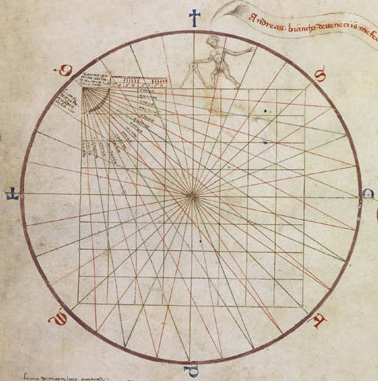
Navigating from point to point is a relatively simple task for most surveyors or mariners. You establish a compass bearing from where you are to your intended location then measure out the distance (or in the case of sailing a speed and a time) to the new location giving what we call today a vector. …
Continue reading “Vector Computations without the Benefit of Modern Trigonometry”
The Colonial Surveyor
The first surveyors in America arrived with the Jamestown Company in 1621. Given the goal of quickly settling Virginia and the vagaries of Royal Charters for Maryland, Virginia, and the Carolina colonies, surveyors were critical to establishing order in the colonies. The role of the surveyor was to transfer land from the crown to private …
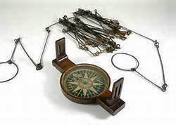
How to Survey Land with 18th Century Tools – Measuring Lines
Land surveys consist of six basic tasks: Determinizing your position on Earth using celestial navigation methods Measuring distances with a Gunter’s Chain. Measuring changes in elevation with a Range Pole Measurement of directions and angles using a Compass. Drawing the map on a Plane Table, and Computing areas with basic plane geometry In this series …
Continue reading “How to Survey Land with 18th Century Tools – Measuring Lines”
How to Survey Land with 18th Century Tools – The Tools

Land surveys consist of six basic tasks: Determinizing your position on Earth using celestial navigation methods Measuring distances with a Gunter’s Chain. Measuring changes in elevation with a Range Pole Measurement of directions and angles using a Compass. Drawing the map on a Plane Table, and Computing areas with basic plane geometry In this series …
Continue reading “How to Survey Land with 18th Century Tools – The Tools”
The Surveyor’s Artificial Horizon
Much of what you read about celestial navigation is focused on ocean navigation where you have a reasonably unrestricted line of sight to the horizon. Terrestial navigators and surveyors often do not have this and must make adjustments in their technique. One very common approach is to use an ARTIFICIAL HORIZON. An “artificial horizon” is …
Colonial Surveyor – Determining your Position using Celestial Navigation
A sextant is an intimidating complex instrument. It consists of an A-shaped frame with an apex of 60° on a sextant or 45° on an octant. Along the rounded lower edge of the frame is an arc, the limb, that is marked with numbers for the degree of the angles that the sextant can measure. An index …
Continue reading “Colonial Surveyor – Determining your Position using Celestial Navigation”
Vector Computations without the Benefit of Modern Trigonometry
Navigating from point to point is a relatively simple task for most surveyors or mariners. You establish a compass bearing from where you are to your intended location then measure out the distance (or in the case of sailing a speed and a time) to the new location giving what we call today a vector. …
Continue reading “Vector Computations without the Benefit of Modern Trigonometry”
