
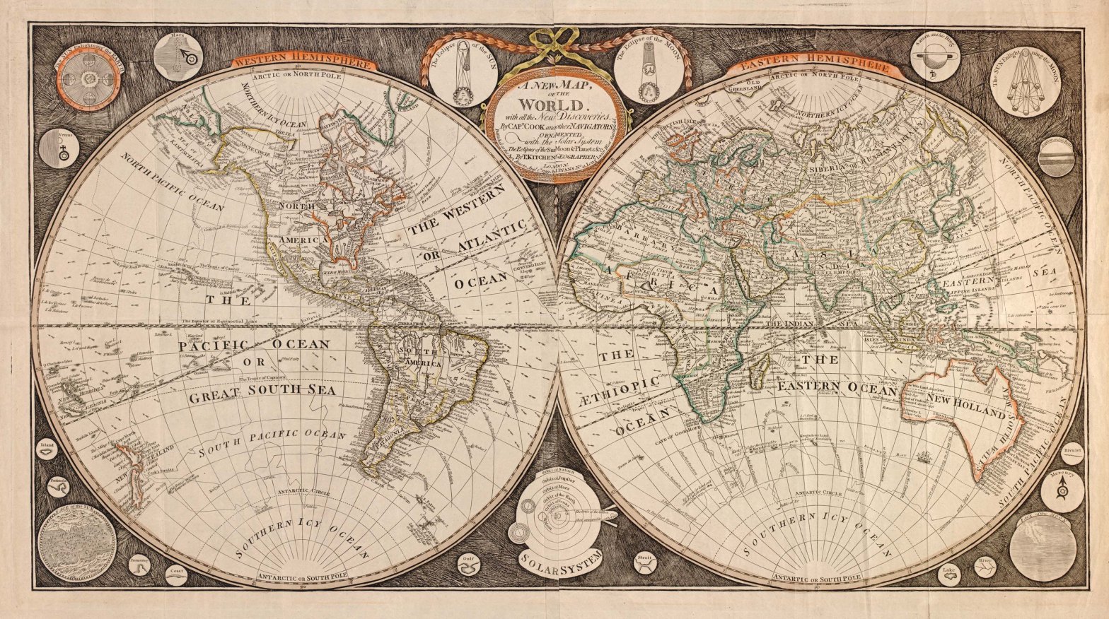
Maps of land surfaces and charts of the sea coasts are scaled down representations of the earth’s surface. They are ideal documents to prove that a discovery has taken place and provide the means for the exploration to be repeated by others. They are tremendous assets to the military and are a great aid to commerce.
Maps are made up of three measurable elements: location, direction and distance. On some maps symbols and elevation are added. Symbols give more meaning to locations while elevation adds altitudinal distance. The precision of these elements and their exact placement on maps relative to each 111 km other, is what separates accurate maps from poor ones. Accuracy is dependent on:
- the precision of the instruments available to make observations,
- the observer’s knowledge of the earth’s shape and size, and its relationship to various points of reference (usually celestial bodies),
- the number of observations that form the basis of the map,
- the mathematics used to make observations and render these into maps, and
- the skill and training of the mapmaker.
By the 16th century there was a general agreement that position be recorded by latitude and longitude. Due to the unvarying relationship between the earth’s axis and the sun and stars, latitude (the angle between a place, the center of the earth and the equator) could be easily calculated. This was done either by measuring the height of the sun at noon above the horizon and correcting that observation for the day of the year (sun’s declination); or, by measuring the height of the North Star (Polaris) and compensating slightly for the difference between the position of Polaris and the geographic pole, since the two do not exactly coincide. To do these tasks two instruments could be used; the astrolabe, mainly used for measurements on land, and the cross-staff (also called Jacob’s Staff) for observations at sea. Sixteenth century measurements of latitude such as Jacques Cartier’s were accurate to about one-quarter to one-half of a degree (one degree latitude equaling about 68 miles).
Longitude, the angle between a place, the earth’s axis and a prime meridian (today the prime meridian is the longitude of Greenwich, England), was impossible to calculate accurately until John Harrison invented the marine chronometer, (a large pocket watch set on Greenwich mean time) in 1773. Since the ancient Greeks, geographers had known that longitude could best be determined by calculating the difference in solar time between two places. Since the earth is 360° in circumference and rotates on its axis every 24 hours, one hour of time equals 15 degrees longitude. One degree therefore, equals four minutes of time and about 111 km at the equator. Since time-pieces were not generally available until late in the 18th century, longitude had to be obtained by estimating east-west distances from a place of departure to a destination. On land, distances were estimated by travel time — for example the distance an average man could walk in an hour. The French called this the “lieu d’une heure de chemin.” Similarly, at sea, the estimated speed of a ship was converted into distance. This was called “dead reckoning.” A navigator kept very careful note of all his speeds, course changes, encounters with currents, etc. in a log book. At the end of the day, he would convert all his observations into distances and plot them on his chart according to his compass observations.
During the early 17th century, mapmaking took a huge leap forward. The instruments had improved; mathematical and astronomical concepts necessary to making accurate measurements had evolved; observers were better trained; and — very importantly — strong motives had arisen to make accurate maps, namely the New World and ensuing military conflicts in Europe.
Before the close of the 16th century, English mathematicians had perfected triangulation (navigation and surveying by right-angled triangles) through plane trigonometry. This development allowed navigators to set courses on any compass angle and permitted surveyors to produce much more accurate surveys on land. Latitude determination was greatly improved with John Davis’s invention (ca. 1595) of the back-staff (Davis quadrant). It was further developed over time and remained unsurpassed until the invention of John Hadley’s reflecting quadrant (1731). The measurement of distance sailed at sea was improved by another English invention, the common log. This device was a line, knotted at fathom (six foot) intervals and attached to a float. The speed of a ship was calculated by heaving the float off the stern and counting the knots as they ran through the navigator’s hands during an interval of 30 seconds or a minute. The result was converted to distance over the time the wind speed was constant — a great improvement over dead reckoning.
Longitudinal distance between Europe and America was determined by solar and lunar eclipses. A predicted eclipse would be timed in some European city (usually Paris or Rome) and at a major city in America (like Philadelphia or Québec). The difference in time between the two observations was calculated and converted to degrees at one hour per 15 degrees. This was an exacting procedure, but good results were obtained by the Jesuit Bressani in the 1640s and by Jean Deshayes in 1686. With fairly accurate surveys in Europe to determining the absolute length of a degree of latitude, and a decree being made by Louis XIII in 1634 to create for the first time a standard prime meridian for French maps (at Ferro, in the Canary Islands), the basic grid of the modern map began to take shape.
What lagged was the education and inclination of navigators and surveyors to take advantage of such innovations as triangulation, more precise compasses, the back-staff, and the common log. In this respect, England moved ahead much faster than other nations with the establishment of training centers for navigators late in the 16th century. The trends of the 17th century became realities in the 18th. Advances in technology, general acceptance of new mathematical and astronomical theories, and rigorous training schools for navigators and surveyors had an increasing impact on the accuracy of maps.
After the mid-18th century, map accuracy increased, primarily due to the development and manufacture of new instruments and stringent training in how to use them. In 1731, John Hadley invented the reflecting quadrant (really an octant), which rapidly replaced the Davis back-staff for latitude observation. The sextant, a finer instrument, was developed out of the octant in 1757. It came into common use before the end of the century and remained in use well into the second half of the 20th century. The invention of the artificial horizon (a box of quicksilver), by George Adams in 1738, made latitude observation possible on land where the real horizon was not visible. The invention of the octant and sextant also made it possible to make reasonably good calculations of longitude by lunar distance, a method invented by David Maskelyne in 1761.
The construction of good high power refracting telescopes made another, older method of longitude calculation possible, by observing predicted eclipses of Jupiter’s moons. In 1766, tables based on the Greenwich meridian and showing lunar distance and the locations of Jupiter’s moons were printed in the Nautical Almanac. These two methods required a great deal of skill and an up-to-date Almanac. It was not until John Harrison invented the marine chronometer and it was tested on James Cook’s second voyage (1772-75) that the problem of longitude calculation was solved.
Map production went through a series of stages, beginning with the field observations of an explorer, a surveyor on land, or a hydrographer or navigator on water. In order to be useful for mapping, their observations had to contain as many precise measurements of distance, direction and location of latitude and longitude as possible. These field observations, in the form of notebooks, ship’s logs and sketched maps, usually went to a professional cartographer, who was often also a geographer. Professional cartographers had access to earlier maps, other field observations, and different information as well as the technical competence to compile these into maps which placed new findings in a broader context.
The main problem for these cartographers was judging the accuracy of the information they received, since they were in no position to verify it. Before the use of mechanical means to reproduce maps, the cartographer’s map would be the final version: a well-drawn, attractively produced manuscript map. Most such maps from the 16th century are unique; rarely was a duplicate made, although some were copied by other cartographers. Many of these maps were commissioned by wealthy patrons or monarchs, or given as presentation pieces much like art. Once a map was produced, the original field sketches were discarded. Once printed maps replaced manuscript maps, cartographers dealt directly with printers. Map reproduction involved two basic steps: the transfer of the cartographer’s image to a printer’s plate and the printing process itself. Both of these steps required specialists. Between the appearance of the first printed map in 1472 and the end of the 19th century, there were three ways of preparing a plate. The first printed maps were produced from smooth wood blocks, in which the image to be printed had been carved in relief by a form cutter. Since wood blocks were fragile, difficult to edit and wore out quickly, they were almost completely replaced by the mid-16th century by a new technique — copper engraving.
Copper engraving involved the preparation of a plate by cutting (incising) the cartographic image into a flat copper sheet. In contrast to wood blocks — where the ink adhered to a raised surface — on a copper plate the ink filled the incising. In both cases the cartographic image had to be cut or incised into the plate or wood surface in reverse, in order to produce a positive image. This required highly trained specialists, really artists. Copper engraving was gradually replaced by lithography during the 19th century. This is a chemical process whereby a raised image is produced on a smooth stone surface by dissolving the unwanted areas with nitric acid. Because the woodcutter and engraver were eliminated, maps could be produced faster and more cheaply. The presses used to transfer the image to paper also varied over time. In general, wood block maps were printed on a flatbed press much like a wine press, with vertical pressure applied to a sheet of paper placed on top of the inked surface. Copper plates made the roller press necessary. This press moved the plate and slightly moistened paper between two rollers, squeezing the two together and forcing the paper into the incised image that held the ink. Both presses required cleaning and re-inking every time an image was printed. Lithographic presses were originally much like flatbed and roller presses but quickly developed their own specialized technology.
