
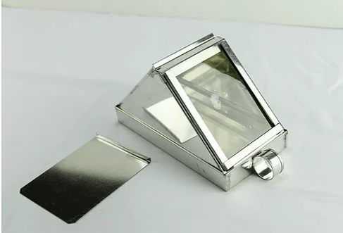
When taking a sight with a celestial object, the observer uses the natural or sea horizon as the line of departure. When, however, that horizon is obscured by darkness or inclement weather such as fog, an instrument known as an “artificial horizon” is used to serve as an alternative to obtain accurate altitude readings. Just like a pilot uses a artificial horizon to stay level in the clouds, the surveyor will use a system of mirrors to estimate the location of the real horizon when on shore.
The artificial horizon consists of a reflecting plane that is parallel to the natural horizon, upon which the rays of the sun or other celestial object fall, and are reflected back to the eye placed in a proper position to receive them. The angle between the real object, and its reflected image being then measured by means of a sextant, is double the altitude of the object above the horizontal plane. The observer using a sextant could dispense with the visible horizon when taking sights of the sun or of a star even when visibility was acceptable by substituting the artificial horizon.
A surveyor on land can experience the same problem while using a sextant to take a sight for finding longitude ashore when no visible horizon is available, such as when taking measurements in a valley or forest. For this reason, the Lewis and Clark expedition, was equipped with three artificial horizons.
Want to Buy Beer from the Colonial Brewmeister?
Help us build a Tavern and Brewery.
Visit our GoFundMe Site
Want the Regimental Brewmeister at your Site or Event?
