

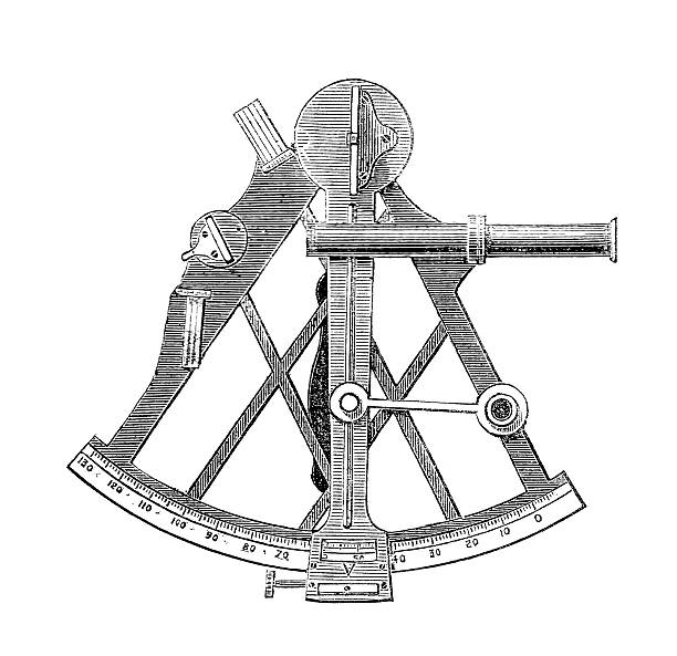
A sextant is an intimidating complex instrument. It consists of an A-shaped frame with an apex of 60° on a sextant or 45° on an octant. Along the rounded lower edge of the frame is an arc, the limb, that is marked with numbers for the degree of the angles that the sextant can measure. An index arm is attached to the frame near the top of the ‘A’, so that it pivots around that point. The arm is also attached to the limb by means of a tangent screw. The index arm can be made to move along the whole arc of the sextant. The index arm has a pointer that points to the arc to indicate the number of degrees that the sextant is measuring. Some modern sextants have a micrometer drum that is graduated in minutes of arc, and each full rotation of the micrometer drum moves the index arm one degree along the arc. This micrometer drum allows the index arm to point to minutes using a vernier scale. At the pivot point of the index arm is a mirror and along one arm of the A-frame is a half-silvered horizon mirror. By aligning these mirrors, the user can align a point in the sky with the horizon. The sextant measures the angular separation between two objects by measuring the angle that the index mirror must be at to bring the two objects into line.
Latitude is determined by observing the altitude of Polaris, the North Star. It can be approximated by measuring any star, planet, or, more commonly, the sun, at the moment of transit. As a star rises in the East and climbs higher and higher in the sky it will eventually reach a maximum height above the horizon (the instant of transit), whereupon it then descends again to the West. The meridian is the line of longitude that passes though the point directly overhead (the zenith). When the sun is on the meridian, it is high noon.

This all works great if you are at sea and have an unobstructed line of site to the horizon. Unfortunately, once you are on land (except perhaps in Kansas) you often can’t get an unobstructed view to the horizon. The solution to the problem is the quicksilver horizon or artificial horizon and the use of double altitudes. Any liquid will form a level with the surface of the earth. A measurement of the angle between an object, and its reflection in the liquid will be twice the angle from the horizontal to the object. Although mercury is the ideal material, due to its high density and good reflectivity, many other liquids can be used with success. Lewis and Clark used water in their artificial horizons on their expedition across Louisiana (1804-1806).
Determining longitude is simpler in theory than determining latitude, but in practice it is much more difficult. The theory is based on the fact that the earth rotates through 360° in 24 hours. If one knows what time it is where they are standing, and one also knows what time it is in Greenwich (the 0th degree of longitude), then, by simply taking the time difference and dividing by 15, one can compute the distance in degrees from Greenwich. To determine the local time, you need to find the exact time of local apparent noon or the moment of solar transit. One way to determine local apparent noon is to observe the sun’s altitude as it approaches noon. Then, once transit has occurred, find the time in the afternoon at which the sun again reaches the same altitude that was measured in the morning. The time of local apparent noon is the difference between the two times, divided by two. A watch can then be set to show the correct local solar time. Determining the time at Greenwich would be straightforward if one had a good marine chronometer but reliable chronometers weren’t perfected until William Harrison won the Longitude in 1735. These devices were also quite large, cumbersome, and suited only to the relatively gentle motions of a ship at sea. The only watches available for the land navigator were small, key-wound, pocket-style watches — often without second hands! Such a watch would be useful for navigation for only short periods of time.
Another way to determine the time at Greenwich, is to employ lunar distances. The moon travels thorough 360° in about 23 days, and therefore moves about ½° per hour. If one measures the angular distance that the moon is from another object on the ecliptic (usually the sun), applies various corrections, and then refers to a lunar distance table listing when such a distance would be observed by an observer in Greenwich, it is possible to determine what time it was in Greenwich at the instant that the observation was made. As long as one’s watch had been set to local time within the last 12 hours or so, longitude could be determined with an accuracy of about 20 minutes of arc.
Yeah, modern GPS is much easier…
