
The first surveyors in America arrived with the Jamestown Company in 1621. Given the goal of quickly settling Virginia and the vagaries of Royal Charters for Maryland, Virginia, and the Carolina colonies, surveyors were critical to establishing order in the colonies.

The role of the surveyor was to transfer land from the crown to private ownership. The survey was completed using a compass on a staff, called a Jacob’s Staff, and a 33′ Gunter’ chain. It was the responsibility of the buyer to be the pilot, showing the land’s boundary to the surveyor and to hire two chain carriers. Once the fieldwork was completed, the surveyor drew a plat and wrote a description of the property. The survey plat and description were copied and entered into the county survey book, and the originals were sent to the Governor. Upon entry of the warrant with survey plat and description, the Secretary of State issued a land patent signed by the governor and marked with the colony’s seal.
Later as significant municipal buildings like Faneuil Hall, the Pennsylvania Statehouse, Carpenters Hall, and significant manor homes like Mt Vernon and built, it was critical that detailed and clear surveys were prepared to aid the architect not only in the design but also in the ultimate construction of these buildings.
During the Revolutionary War, George Washington, himself well-schooled in surveying, commissioned a battalion of surveyors and geographers to map the terrain ahead of the army. A knowledge of the terrain, location of roads, fords, and various other aspects of the land was vital to the ability to effectively move the army and wage war.
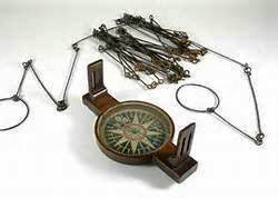
The basic instrument used by colonial surveyors was the compass, commonly called a circumferentor. The compass was mounted on a base, which extended into two arms set opposite each other. At each end of the arms are sighting vanes consisting of an oval and a narrow slit with a thin wire or horsehair stretched over the oval, providing precision in sighting. The surveyor sights the compass by peering through the slit in one end and lining up the horsehair in the oval of the other vane with a target in the field.
Since land is measured in terms of area a certain amount of mathematical acumen is required to be a surveyor. The basic unit of land measurement is the acre which is 10 square chains and in places like cities where the plats are square, measuring square chains is straightforward but what if boundaries of the land follow a stream or other non-straight line?

The rudiments of plane geometry (areas of squares, triangles, circles, etc) were have been well known since Pythagoras but the mechanics of these computations in a era when all work is done by hand (no computers!) can make reckoning a the area of a large irregular plot of land somewhat complex and tedious. There were, however, computational aids such as the Gunter’s Rule, alidade, and basic draftsmen’s tools like dividers.
The Alidade allows the surveyor to sight a line directly on the plane table. Basically, a straight edge with gun sights, the surveyor can match a line sighted with a compass directly to the paper map as it is drawn.
Gunter’s rule has both a linear and logarithmic scale allowing basic multiplication, division, addition and subtraction to be made by with calipers simply adding scales.
