
Following the Seven Years War, the aristocrats who gathered in Paris in February 1763 divided up North America belonged to sort of a huge gambling sort. The war started in 1754 as a skirmish between France and Britain in the Ohio River Valley but eventually exploded into a worldwide conflict. The imperial powers attacked each other’s colonies across the globe — in the Americas, Africa, India, and, after Spain foolishly and belatedly joined as France’s ally, the Philippines. By 1763, Britain had emerged victorious, if nearly bankrupt, and all that remained was to finalize a peace.
In the course of the lengthy negotiations, the adversaries traded islands and continents like poker chips. Minorca for Guadeloupe and Gorée; Louisiana for Martinique; Florida for Havana and the Philippines; St. Lucia for Grenada, Tobago, and St. Vincent. Demands flew back and forth: evacuate Bung Hun on Sumatra and Ostend and Nieuwpoort in the Austrian Netherlands; dismantle the logwood settlements on Central America’s Gulf Coast; cede rights to Canada’s cod fisheries. The emissaries bargained and plotted, deceiving their enemies as well as their allies.
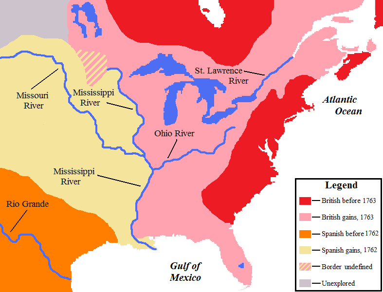
From the perspective of North Americans, the most important provision of the treaty was the one that divided their continent between rival empires. An imaginary line as created between the Mississippi and the Appalachians. The challenge was to create a border that was clear and easily maintained. The French minister pointed out that there were numerous precedents for a border defined by geometry rather than geography, including the meridian that had apportioned newly discovered lands between Spain and Portugal in 1494. Unlike the Appalachians, which extended in a very irregular manner were poorly represented on most maps of the era, an artificial line would leave little argument in the treaty. Britain pushed instead to divide the continent along the Mississippi River for the same reason. The logic seemed faulty even to those who espoused it, for the river had multiple channels and its eastern bank had many well-established Spanish settlements which would be impossible to dislodge. Britain won the day, however, and the Mississippi became the border, with the occupants of both sides having the right to navigate its waters. To obtain Spain’s acquiescence, France’s Louis XV gifted his portion of the continent to Charles III.
On February 10, 1763, the ambassadors assembled at the Hôtel de Grinbergen and signed the ‘definitive’ treaty that shaped the fate of North America. Before the war, France had claimed an immense domain stretching from the St. Lawrence to the mouth of the Mississippi; Spain had possessed the Southwest and greater Florida whose western border was near present day Louisiana (subsuming present-day Alabama and Mississippi). Britain had presided over its Atlantic colonies. In the treaty’s aftermath, the political geography was vastly simplified. Everything west of the Mississippi River belonged to Spain and everything east of it to Britain, with the important exception of New Orleans.
