
We will be conducting an 18th Century Surveying Class on May 29th at Fort Mifflin. Join us to learn the art and science of surveying the land in the 18th century manner. We will measure and map the Fort interior at 11 am and learn basic surveying and mapping skills then take a “Wilderness” expedition of the High Battery at 1 pm.
The first surveyors in America arrived with the Jamestown Company in 1621. Given the goal of quickly settling Virginia and the vagaries of Royal Charters for Maryland, Virginia, and the Carolina colonies, surveyors were critical to establishing order in the colonies.
The role of the surveyor was to transfer land from the crown to private ownership. The survey was completed using a compass on a staff, called a Jacob’s Staff, and a 33′ Gunter’ chain. It was the responsibility of the buyer to be the pilot, showing the land’s boundary to the surveyor and to hire two chain carriers. Once the fieldwork was completed, the surveyor drew a plat and wrote a description of the property. The survey plat and description were copied and entered into the county survey book, and the originals were sent to the Governor. Upon entry of the warrant with survey plat and description, the Secretary of State issued a land patent signed by the governor and marked with the colony’s seal.
Later as significant municipal buildings like Faneuil Hall, the Pennsylvania Statehouse, Carpenters Hall, and significant manor homes like Mt Vernon and built, it was critical that detailed and clear surveys were prepared to aid the architect not only in the design but also in the ultimate construction of these buildings.
During the Revolutionary War, George Washington, himself well-schooled in surveying, commissioned a battalion of surveyors and geographers to map the terrain ahead of the army. A knowledge of the terrain, location of roads, fords, and various other aspects of the land was vital to the ability to effectively move the army and wage war.
This will be an interactive program where participants are encouraged to employ the tools and techniques of the 18th Century Surveyor and actively measure a section of Fort Mifflin. Participants will be allowed to site lines using the compass and range poles. They will be allowed to measure those lines using the Gunter’s chain as well as measure splines off that lines for irregular boundaries. Finally, participants will be encouraged to use these measurements to draw maps and write property descriptions (which they may take away).

Most surveying expeditions require three sets of measurements: 1) geometry, measuring the earth; 2) geography, making a pictorial representation of that measurement; and 3) navigation, determining your location and track on earth. For simplicity, we have chosen to focus only on the first two of these in today’s program.
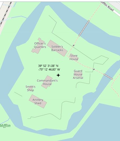
Normally, a surveyor needs to establish their position using celestial sightings. Latitude is measured, in the northern hemisphere, as the angle between the horizon and the North Star (Polaris). Longitude is more complicated to determine but is essentially the distance east or west of the palace at Greenwich and is established using local noon, the time when the sun is at zenith, and a calibrated chronometer set to Greenwich time. Because these sightings must be done at specific times of the day (Solar Noon = 12:57 on 5/29/21 in Philadelphia, and Polaris must be sighted after dark), we will use a known location within the fort as our reference point (the northeast corner of the Commandant’s Headquarters is at Latitude 39° 52′ 31.08″ and Longitude -75° 12′ 46.80″ W) then determine our locations by deduced reckoning (AKA Dead Reckoning) and path integration from that known location.
Our measurements will be taken using the primary tools of the 18th Century Surveyor: the compass and the Gunter’s chain. The surveyor’s compass, or circumferentor, incorporates both a magnetic needle, that points north, and a set or gunsights or alidade sites that allow a line to be measured relative to the direction of the needle. By measuring the angle between magnetic north (often different than the true north under Polaris) we establish a bearing or direction for our measurements. Once that bearing is established, we need to measure distances and that is done using Gunter’s Chain.
Gunter’s chain was introduced by the English clergyman and mathematician Edmund Gunter in 1620 to eliminate a controversy over distance measurements. Historically, many units had various definitions depending upon where you were and how you used those units. For example, an acre is traditionally defined as the area of land that can be plowed by one man and a team of eight oxen in one day. Of course, depending on the man and the ox, this area might be very different. To eliminate this ambiguity, the Henry VII (NOT HENRY VIII!) established a series of legal definition for length and weights to be used throughout the realm. Now an acre was established as 66 feet × 660 feet (43,560 square feet) or ten square chains. Similarly, a mile which was customarily defined as 1000 military paces (about 5300 feet) become 80 chains or 5280 feet.
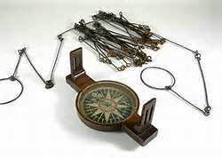
Gunter’s chain is a 66-foot steel chain, divided into 100 links usually marked off into groups of 10 by brass tags which simplify intermediate measurement. Each link is thus 7.92 inches long. Edmund Gunter employed this chain to reconcile two seemingly incompatible systems: the traditional English land measurements, based on the number four, and decimals based on the number 10. Since an acre measured 10 square chains in Gunter’s system, the entire process of land area measurement could be computed using measurements in chains, and then converted to acres by dividing the results by 10. Hence 10 chains by 10 chains equals 10 acres, 5 chains by 5 chains equals 2.5 acres.
Today’s program is in two parts to represent two very important but quite different experiences of surveyors in early America. We will start with program on urban surveying using an established military encampment and creating a detailed rendering of a small section of land in a manner similar to what would be done during a construction project.
Session 1: 11:00 – 12:00
Mapping the Fort (urban surveying)
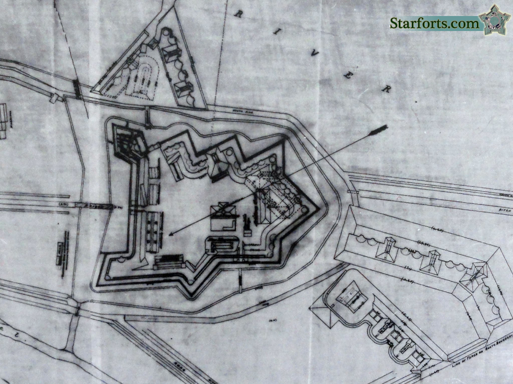
In this session, the class will be afforded all the benefits of an established base camp (tables, computing equipment, drafting tools, shade, etc) and will take detailed measurement of one of the bastions of the fort in the same manner as would be done for an artillery emplacement. Participants will be encouraged to take measurements (hands on) using reproduction 18th Century equipment and produce a map (which they may take home) of the bastion complete with all the necessary measurements, computations, and location information.

Session 2: 1:00 – 2:00
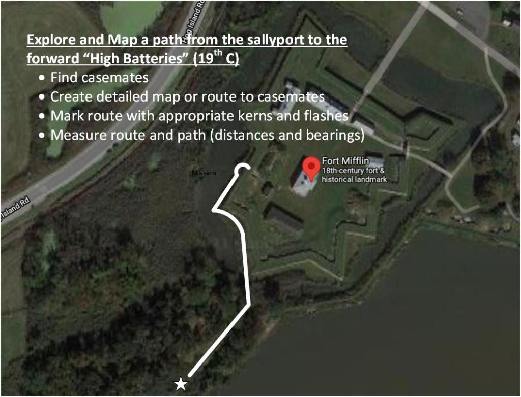
Wilderness Survey (beyond fort’s walls)
The afternoon session is very different type of survey. As an exploratory patrol — with an armed escort to protect them from enemy soldiers, Indians, wild animals, or other threats – this survey team will be sent to discover and report the location of the 19th Century forward high batteries south of the fort’s wall. This expedition will need to maintain distances and bearings from the fort’s sallyport (and ultimately the known location by the Commandant’s Headquarters), mark the trail using kerns and blazes, find the casemates based on a scout’s description of its location, then return to camp and recreate that path as a map. This is the type of survey that was done of new lands on the frontiers of Lord Fairfax’s Northern Neck Proprietary by George Washington in the early 1750’s or by Captain Meriwether Lewis and Second Lieutenant William Clark when sent by President Jefferson to explore and map the territory from the Louisiana Purchase in 1803.
For more information or to register for this event see http://www.fortmifflin.us/event/colonial-surveyor/
