
Navigating from point to point is a relatively simple task for most surveyors or mariners. You establish a compass bearing from where you are to your intended location then measure out the distance (or in the case of sailing a speed and a time) to the new location giving what we call today a vector. Travel in the desired location for the desired length of time and you should arrive at the location. But what happens when you have to navigate around an obstacle?
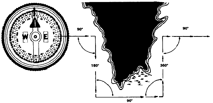
This happens frequently. Perhaps you have a barrier, as shown, or perhaps you are sailing and the winds are not blowing in the direction you want to sail. How do you ensure that your adjusted course matches the intended track? Obviously when the offset is simple, like in the picture, you simply reverse the course adjustment (like in city blocks) and return to the desired track but what happens when the deviation is not square or simple, or if you must navigate around multiple obstacles? What do you do when your course corrections are not simple?
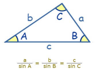
Well, in the modern world, this is no real issue. Modern navigators and surveyors are able to use simple trigonometry to calculate the offsets from their intended course and then add these up until they have returned to the plotted course. We do this using the Law of Sines. The issue is that in the 18th Century, computing those Sine values for most angles is beyond the computational abilities of most, even well educated, navigators or surveyors and trigonometric tables were rare and quite expensive.
Today, we have tables of trigonometric values and even electronic calculators to do the arithmetic but an 18th Century Surveyor had to do all these computations by hand. Yes, you CAN do all this by hand but it is tedious so like other routine mathematical operations, a computational device was employed.
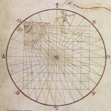
The visual device known as the “circle and square” (tondo e quadro) was created by Andrea Bianco in his 1436 atlas. The circle was a 32-wind compass rose (or gathering of rhumb-lines). The circle was inscribed with an 8 × 8 square grid. This graphical construct allows the navigator to plot a course in one direction (a vector), then read the distance traveled in the intended direction (intended vector) without having to do the computations of sine. Modern pilots have a similar device on the back of their E6B slide rules.

Suppose you planned to sail 120 miles on a heading of 90° (due East) but because of the prevailing winds, you were forced to sail om a course of 120° and have travelled 120 miles. How much progress have you made toward your intended destination and what course must you now plot to reach that destination?

Using the “circle and square” dispenses manipulating numbers by multiplication and division and allows us to simply measure a distance along a line in the direction of 120° then following the grid to our intended course line, read the progress we have made (111 miles). We can also plot the course back to our desired course, 30°, and using dividers, directly measure the remaining distance we must travel, 46.5 miles. All without doing any numerical computations.
Now clearly, we could have done these same computations at sea using celestial navigation (to determine our location) and a map but the surveyor working in mountainous or wooded terrain may not always have that option so this ancient tool survived well into the 20th Century (especially in aviation) as an important addition to our dead reckoning skills.
In the Colonial Surveying class that I will teach at Fort Mifflin on May 29th, our surveyors will navigate a complex track outside the fort’s walls with no line of sight either from the beginning of the path to the end (the fort will be in the way) nor to the horizon (wooded area). We will be employing tondo e quadro and the Law of Sines (but leaving our pocket calculators behind) to determine where we are relative to a known location within the fort.

